
Introduction
Spain, located in the southwestern corner of Europe, is a country that has fascinated travelers, historians, and geographers for centuries. A map of Spain is more than just a visual representation of its borders; it is a gateway to understanding its diverse landscapes, rich cultural heritage, and vibrant cities. From the snow-capped Pyrenees to the sun-drenched Mediterranean coast, Spain’s geography is as varied as its traditions. Maps help us navigate this complexity, offering insights into the nation’s past, present, and future map of spain.
For tourists, a map of Spain is essential for planning journeys across bustling cities and serene countryside. For students, it is a tool to study geography and history. For researchers, it provides data on climate, land use, and urban development. This article explores Spain through its maps, covering geography, administrative divisions, cultural significance, and practical uses.
Geographic Overview of Spain
Spain occupies most of the Iberian Peninsula, sharing borders with Portugal to the west, France and Andorra to the north, and Gibraltar to the south. Its eastern and southern coasts are washed by the Mediterranean Sea, while the northern coast meets the Bay of Biscay. This strategic location has made Spain a crossroads of civilizations for thousands of years.
The geography of Spain is defined by striking contrasts. The Pyrenees form a natural barrier with France, while the Sierra Nevada in Andalusia boasts some of Europe’s highest peaks. The Meseta Central, a vast plateau, dominates the interior, influencing climate and agriculture. Rivers such as the Ebro, Tagus, and Guadalquivir carve through the land, shaping valleys and fertile plains.
Spain’s climate zones add another layer of diversity. The north enjoys a temperate, oceanic climate, while the Mediterranean coast is warm and sunny. Inland regions experience extremes, with hot summers and cold winters. These variations make Spain a land of contrasts, where geography directly influences lifestyle, agriculture, and tourism.
Administrative Divisions and Regions
Spain is divided into 17 autonomous communities and two autonomous cities, each with its own government and cultural identity. These regions reflect centuries of history and local traditions. For example, Catalonia and the Basque Country are known for their distinct languages and strong regional pride, while Andalusia is celebrated for flamenco and Moorish architecture.
Within these communities are 50 provinces, each with unique features. Madrid, the capital, is located in the heart of the country, serving as Spain’s political and cultural hub. Barcelona, in Catalonia, is famous for its modernist architecture and Mediterranean charm. Seville, Valencia, and Bilbao each add to Spain’s rich tapestry of urban life.
Maps of Spain highlight these divisions, showing how geography and culture intertwine. They reveal the diversity of languages spoken—Spanish, Catalan, Basque, Galician—and the traditions that make each region unique. Understanding these divisions is crucial for travelers, students, and anyone seeking to grasp Spain’s complexity.
Historical and Cultural Significance
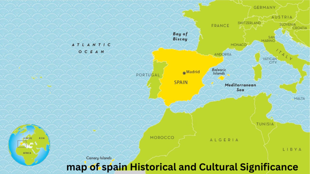
Spain’s maps are not just geographical tools; they are historical documents. Ancient civilizations such as the Romans and Moors left their mark on Spain’s borders and cities. Historical maps show how Spain expanded during the Age of Exploration, becoming a global empire with territories across the Americas, Africa, and Asia.
Cultural landmarks are scattered across Spain’s map. UNESCO World Heritage sites such as the Alhambra in Granada, the historic center of Toledo, and Gaudí’s works in Barcelona highlight the country’s artistic and architectural achievements. Each site tells a story of Spain’s past, from medieval kingdoms to modern innovation.
Maps also reflect Spain’s cultural diversity. Festivals, traditions, and cuisines vary from region to region. For example, the Running of the Bulls in Pamplona, the tomato fight of La Tomatina in Buñol, and Semana Santa processions in Seville all showcase unique local identities. A map of Spain helps connect these cultural dots, offering a holistic view of the nation’s heritage.
Travel and Tourism with the Map of Spain
For travelers, a map of Spain is indispensable. It highlights popular destinations such as Madrid’s Royal Palace, Barcelona’s Sagrada Familia, and Seville’s Alcázar. Coastal maps guide tourists to beaches along the Costa del Sol, Costa Brava, and Canary Islands.
Spain’s transportation networks are also mapped extensively. High-speed trains (AVE) connect major cities, while highways and airports make travel efficient. Maps help tourists plan routes, whether exploring the wine regions of La Rioja or hiking in the Pyrenees.
Tourism maps often include cultural routes, such as the Camino de Santiago pilgrimage trail. They also highlight natural parks like Doñana and Picos de Europa. By combining geography with travel information, maps of Spain become essential companions for anyone exploring the country.
Educational and Practical Uses
Beyond tourism, maps of Spain serve educational and practical purposes. Students use them to study geography, history, and environmental science. Researchers rely on maps to analyze urban growth, climate change, and land use.
Digital maps have revolutionized how we interact with Spain’s geography. Interactive tools allow users to zoom into regions, explore cultural sites, and plan trips. Satellite imagery provides real-time data for environmental studies and disaster management.
Maps also play a role in urban planning and governance. They help policymakers design infrastructure, manage resources, and preserve natural landscapes. In classrooms, maps of Spain inspire curiosity, helping students connect geography with culture and history.
Conclusion
The map of Spain is more than a geographical outline—it is a window into a nation’s soul. It reveals the diversity of landscapes, the richness of culture, and the depth of history. From mountains and rivers to cities and festivals, Spain’s map connects people to places and traditions.
Whether used for travel, education, or research, maps of Spain remain vital tools. They help us understand how geography shapes culture, how history influences identity, and how modern technology enhances exploration. In essence, the map of Spain is a guide to discovering one of Europe’s most fascinating countries map of spain.
FAQs
What are the major regions shown on the map of Spain?
Spain has 17 autonomous communities and 2 autonomous cities.
Which cities are most important for tourists to locate on the map?
Madrid, Barcelona, Seville, Valencia, and Bilbao are key tourist destinations.
How many provinces does Spain have?
Spain is divided into 50 provinces.
What role do maps play in studying Spain’s history?
Maps show how Spain’s borders and territories evolved over centuries.
Are there interactive online maps available for Spain?
Yes, digital maps provide detailed, interactive views of Spain’s geography.
Which natural landmarks are highlighted on the map of Spain?
The Pyrenees, Sierra Nevada, and major rivers like the Ebro and Guadalquivir.
How can students use the map of Spain for learning geography?
Students can study climate zones, landforms, and cultural regions through maps.
Next Read: lyla in the loop